| Cemetery Number | SK095 |
| Town | SOUTH KINGSTOWN |
| Cemetery Name | QUAKER LOT |
| Find A Grave (Opens in New Tab) |
Go to Find a Grave
|
| Graves List | Display Graves List |
| Location | ROUTE #1 |
| State | RI |
| Direction | W |
| Pole Number | |
| Distance | 100 |
| Map Number | |
| Page Number | |
| Plat Number | |
| Deed Book | |
| Deed Page | |
| Size in Feet | 90 |
| Size in Feet | 110 |
| Burials | 131 |
| Inscriptions | 12 |
| Fieldstones | 119 |
| Tombs | |
| Exist? | YES |
| Last seen date? | 2003 |
| Newest | 1870 |
| Oldest | 1714 |
| Vandalism | N |
| Veteran | |
| Pole | G |
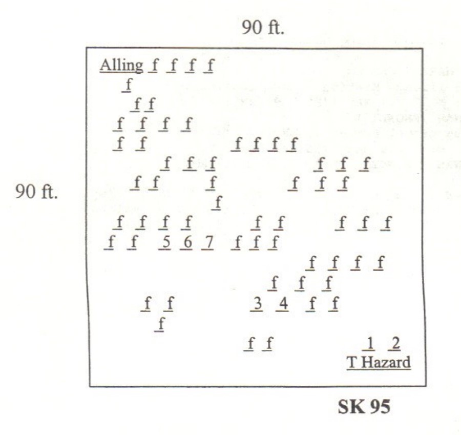
| Comment | This cemetery, cared for by the Pettaquamscutt Historical Society, is located in a triangle bounded by Route #1, Main Street in Wakefield, and an access road named Kelley Way. There are stone walls on the east and west boundaries. It is 90 feet x 110 feet, in good condition, and the historical cemetery sign is in good condition. It contains about 131 burials with twelve inscribed stones and 119 unmarked fieldstones.
The Quaker religion discouraged elaborately carved gravestones until 1852; before that date many Quakers used plain fieldstones with no inscription. Several sources were consulted to learn more about the people buried here. The “Kings Towne Record of Friends,” published in Arnold’s Vital Record of Rhode Island, 1636-1850, 7:213-234, notes many burials here. “Nailer Tom” (Thomas B.) Hazard, an active Quaker, noted in his diary 1,463 deaths from 1778 to 1840, 36 of which were identified as being buried in this yard. Many of those buried here were not only members of his church but were also related to him. As usual, Daniel Stedman noted interesting tidbits for the years 1826 to early 1859 in his journal.
There are two memorial stones in this cemetery. On the back of the memorial stone set by Caroline Hazard in 1917 for “College Tom” Hazard is the following inscription: “In Memory of many members of the Society of Friends in Narragansett whose bodies were here committed to unmarked graves in the lively hope of a glorious resurrection when they shall know even as they are known. This land a part of the Pettaquamscutt purchase of 1657 was sold by Samuel Sewall to Thomas Hazard 1698 and by him to the Meeting 1710.”
James N. Arnold recorded this lot Mar. 6, 1880, his #58, “in the ancient Friends cemetery on Tower Hill near the T. H. Knights house about 1/2 mile northeast from Wakefield Village. This lot is in wretched order overgrown with briers and brush and poorly protected.” He noted that the three Alling [Allen] table stones were located in the extreme northeast corner of the lot in 1880. They were moved to the Peace Dale Congregational Church in 1917. Arnold further noted “82 large and 32 smaller graves in this lot besides those we before mentioned marked by rude stones only, no doubt others are here but have lost their distinguishing mark, others have been removed.
Recorded by John Sterling and James Wheaton for a 2004 book on South Kingstown cemeteries. |
| Condition | good |
| Enclosure | stone wall |
| Gate | no gate |
| Growth | grass-well kept |
| Terrain | hilly steep |
| Cemetery Location |
|
| Cemetery Burial Map |
|
| |
|