| Cemetery Number | CY096 |
| Town | COVENTRY |
| Cemetery Name | GREENE-COOKE LOT |
| Find A Grave (Opens in New Tab) |
Go to Find a Grave
|
| Graves List | Display Graves List |
| Location | WATERMAN HILL ROAD |
| State | RI |
| Direction | S |
| Pole Number | 124 |
| Distance | 50 |
| Map Number | |
| Page Number | |
| Plat Number | |
| Deed Book | |
| Deed Page | |
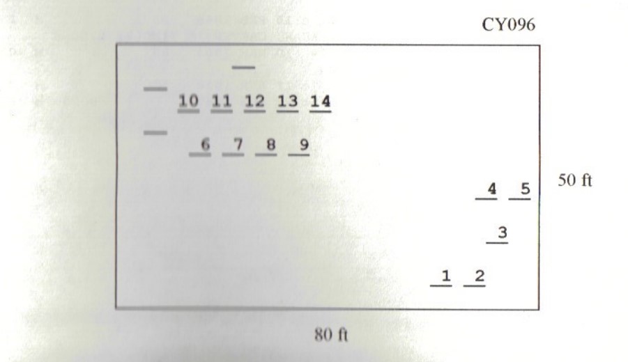
| Size in Feet | 80 |
| Size in Feet | 50 |
| Burials | 20 |
| Inscriptions | 16 |
| Fieldstones | 4 |
| Tombs | 0 |
| Exist? | YES |
| Last seen date? | 2013 |
| Newest | 1838 |
| Oldest | 1743 |
| Vandalism | N |
| Veteran | 0 |
| Pole | G |
| Comment | This lot is located 50 feet south of Waterman Hill Road at telephone pole #124, across from the Waterman-Vaughn Cemetery (Coventry Historical Cemetery #13). The walled enclosure is right beside the road, but many of the burials are about 50 feet back. All slate stones are 1 1/2-inch thick, plain slate. The Greenes have the dates in Quaker format, while the Cookes do not. The cemetery is 80 ft x 50 ft, in fair condition, and enclosed with a stone wall. The historic cemetery sign is in good condition. There are 17 burials with 14 inscribed stones and three fieldstones. This cemetery contains some of the oldest inscribed gravestones in Coventry.
James N. Arnold visited on 25 Jul. 1905 and noted, “Location on Waterman Hill, from information by Arthur James” (Vol. 6, Book A, page 1035).
Recorded by Dr. Bill Eddleman and John Sterling for a 1998 book on Coventry cemeteries |
| Condition | fair |
| Enclosure | stone wall |
| Gate | no gate |
| Growth | overgrown-trees |
| Terrain | hilly moderate |
| Cemetery Location |
|
| Cemetery Burial Map |
|
| |
|