| Cemetery Number | CY019 |
| Town | COVENTRY |
| Cemetery Name | HALL-MOORE LOT |
| Find A Grave (Opens in New Tab) |
Go to Find a Grave
|
| Graves List | Display Graves List |
| Location | VICTORY HIGHWAY (ROUTE 102) |
| State | RI |
| Direction | W |
| Pole Number | 101 |
| Distance | 20 |
| Map Number | 322 |
| Page Number | |
| Plat Number | 2.1 |
| Deed Book | |
| Deed Page | |
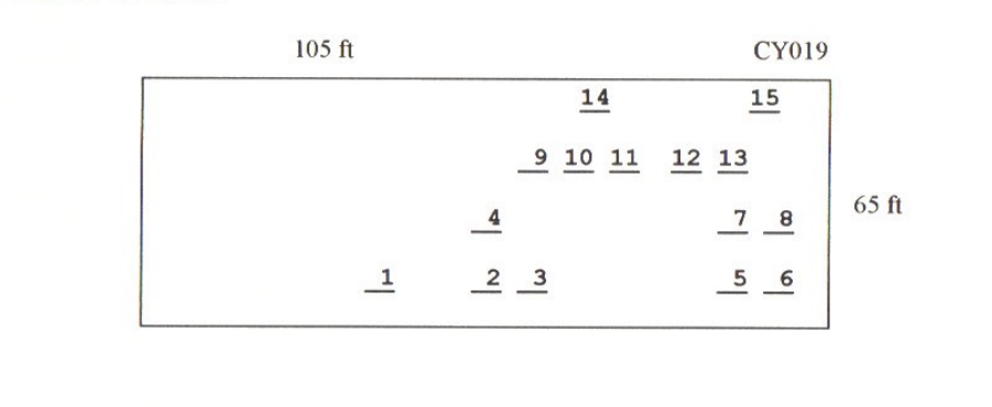
| Size in Feet | 105 |
| Size in Feet | 65 |
| Burials | 26 |
| Inscriptions | 15 |
| Fieldstones | 0 |
| Tombs | 0 |
| Exist? | YES |
| Last seen date? | 2013 |
| Newest | 1991 |
| Oldest | 1891 |
| Vandalism | N |
| Veteran | 2 |
| Pole | G |
| Comment | This lot is located 20 feet west of Victory Highway (Route 102) at telephone pole #101. It is 105 ft x 65 ft, in excellent condition, and enclosed with granite posts and iron rails with a chain gate. The historic cemetery sign is in good condition. There are 26 burials with 15 inscribed stones. It is on the tax assessor’s map, map #322 Lot #2.1.
ames N. Arnold visited on 25 Jul. 1905 and noted, “On Emery Hall place on the road from Summit to Bowen Hill, not protected, one grave that of Mr. [Emery A.] Hall. Recent grave” (Vol. 6, Book A, page 1038). Arthur James (in Arnold data), “Ruel Sheldon farm, near Summit”.
Amelia K. Whitford also recorded this lot.
Recorded by Dr. Bill Eddleman and John Sterling for a 1998 book on Coventry cemeteries |
| Condition | excellent |
| Enclosure | granite posts/iron rails |
| Gate | chain |
| Growth | grass-well kept |
| Terrain | level |
| Cemetery Location |
|
| Cemetery Burial Map |
|
| |
|